Overview
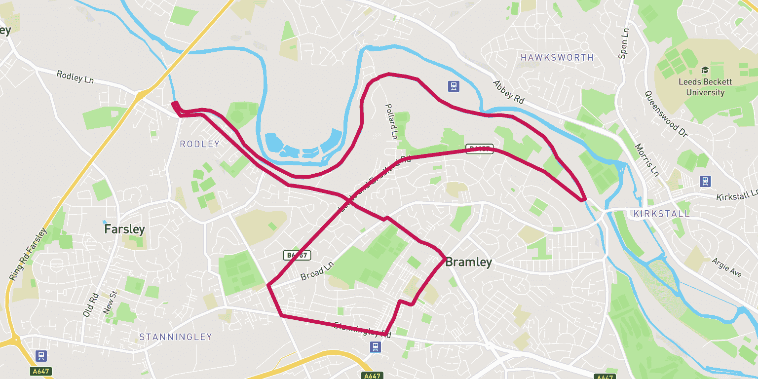
If an out and back canal route bores you then this route is great alternative to run the Leeds Liverpool Canal at distance and get a loop in. The route is a mix of road and canal that takes in the areas of Bramley and Rodley.
From a runners point of view you will run through the peaceful woodland of Bramley Falls, in contrast to the concrete of the streets of Bramley and Stanningley.
Wanting to find your way to the start of the route? Here is a link for a Google Maps Directions page.
This route has a distance of 12.87km and an elevation gain of 220m.
The largest non-stop incline begins in the final third of of the route, and has a distance of 1140m and an elevation gain of 54m. You can see this on the above elevation chart in red.
The largest continual decline is 693m long with an elevation drop of 54m which starts near the start of the route. This is shown on the chart as green.
Route Highlights
The most pleasant part of this run is the Leeds Liverpool Canal stretch past Bramley and Rodley. You'll pass some lovely spots around Bramley Falls, in particular the junction where river, canal and rail all meet on the edge of the ancient woodland. Take a break - it's fine! - just pause that tracker!
Best Time To Run
The best time to run the Bramley, Rodley and Kirkstall Loop is during the early months of spring. Not only will the weather be more forgiving underfoot (and solid!) but you also have the opportunity to appreciate the wildlife and plant-life coming into bloom.
Route Description
Starting on the corner where Stanningley Road meets Hough Lane, head up the lane and take a left at Upper Town Street. This stretch is gentle section of downhill running.
Next run along Upper Town Street and onto Upper Rodley lane. This section is a fairly flat and straight one. We recommend setting a good pace on the second section!
Continue on Upper Rodley Lane which blends into Town Street. Follow this stretch until you reach Rodley Barge. Take a right after the barge and follow this until you reach a small canal bridge. Cross this onto the tow path and take a right.
Coming down the canal you will pass Rodley Sports Ground and Fallwood Marina. This section is a popular area with the public so you’re likely to pass walkers and cyclists here.
For the next few miles you will follow the Leeds Liverpool Canal down past Bramley Fall Woods. Run this until you reach a road bridge just past Kirkstall Abbey (you will see the Abbey on the left as you run down).
Take a right when you get onto Leeds Bradford Road and follow this for a mile or so until you hit Swinnow Lane.
Now you’re into the final stretch. Take a left at Stanningley Road and continue on until you hit the start of the run route – nicely done!
Warnings
As a section of this route is set alongside a main road we recommend you take care when crossing. As well as this the canal can sometimes get busy with walkers and cyclists. If you are running by yourself this can be solved by sticking to the left, while keeping your ears open for the unmistakable sound of a bike bell!
Location
The location of this route is a real mix. You start on Stanningley Road, one of the more busy roads in Leeds, but very quickly end up tucked away from the traffic along the canal.
The route passes a number of green spaces such as Bramley Falls, Bramley Park, Rodley Sports Ground, Rodley Nature Reserve, Kirkstall Abbey and Stanningley Park. All in 13km!
If you like running in this area, why not take a look at some other routes in similar areas. This route went through: Kirkstall.
Amenities
The stretch of canal is well catered for rubbish collection with bins dotted all the way along the towpath route.
If you’re running the route by the canal side the best place to use the toilet is the Abbey Inn just before Fallwood Marina and off Pollard Lane next to Bramley Falls. If you find yourself caught short in Bramley near the Upper Town Street and Hough Lane turning check the Weatherspoons a few minutes off-piste.
Parking
The best place for parking for this route would be the on-street parking on Elder Road – postcode LS13 4DL (Google Maps directions) – this start point is also accessible by Bramley train station which is around the corner.
Food and Drink
The first section of the route along Stanningley Road has a number of food and drink establishments if you are looking for a quick takeaway. We would recommend Scufflers. A little bit further along the road there is Quick Snack.


