Overview
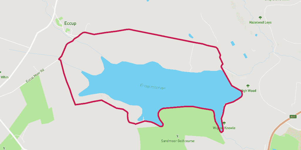
This route around Eccup Reservoir is a great choice if you are looking for a mix of scenery. It takes in the views of the water, as well as surrounding woodland and farms. So much to see on this exciting 6km run.
Wanting to find your way to the start of the route? Here is a link for a Google Maps Directions page.
This route has a distance of 6.17km and an elevation gain of 109m.
The largest non-stop incline begins in the second third of of the route, and has a distance of 356m and an elevation gain of 16m. You can see this on the above elevation chart in red.
The largest continual decline is 180m long with an elevation drop of 15m which starts towards the back end of the route. This is shown on the chart as green.
Route Description
Starting on Manor House Lane, this route is a tough one to get lost on.
Head out across the path along the top of the reservoir, and take the dirt path on the left just after the black gate (once over the water). Follow this path and you will make it onto a tarmac road the other end.
Follow the road between the fields. This part is great on a sunny day! This road goes for a while, and when you come across splits in the road, always stay left.
Continue on this road until you reach two gates on the left, with a stile between them. Cross the stile here and take the left track. This is a fairly straight run and you will come across another stile.
Cross this stile and continue along the track alongside the fence line. At the bottom of the fence there will be another stile, here you climb it and take a left along the bottom of the field.
Follow this path along the edge of the field until you reach a gate on your left. Go through this and begin your approach to the reservoir. Staying on this path will eventually bring you back yo where you began.
Warnings
You may need to pay attention to your footing in the winter or after rain as some of the track can get muddy. Be careful of cars on the top section of the route as the routes can get narrow.
Watch your step when climbing stiles on this route as they can become slippery in wet weather. And take extra care if a stile is broken.
Location
Eccup Reservoir is located 7 miles north of Leeds. Based in the suburb of Alwoodley, just around the corner from the village of Eccup.
The reservoir is a site of scientific interest due to the variety of birds that inhabit the area. There are over 150 different types of birds!
Owned by Yorkshire Water, Eccup Reservoir was built in 1842, and then expanded in the 1850’s an again in the 1890’s. It is thought that it was built on top of a Roman settlement.
For more info on Eccup Reservoir take a look at Discover Leeds.
Amenities
The nearest toilet facilities are at the nearby New Inn pub.
Parking
We recommend parking on Manor Lane, by the start of the route. The postcode is LS17 9NA (Google Map Link).
Food and Drink
The New Inn Pub is North of the reservoir. If you are looking for a bite to eat after your run this would be the closest option. It does standard pub grub and there is a beer garden.


