Overview
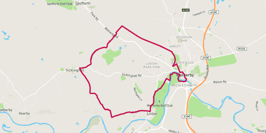
The Sicklinghall run gives you a circular tour of some of the most beautiful towns and villages north of the River Wharfe.
Highlights include the quaint villages of Sicklinghall and Linton, the grade 1 listed country house of Stockeld Park, and the bustling river side market town of Wetherby.
Wanting to find your way to the start of the route? Here is a link for a Google Maps Directions page.
This route has a distance of 13.58km and an elevation gain of 231m.
The largest non-stop incline begins in the final third of of the route, and has a distance of 387m and an elevation gain of 26m. You can see this on the above elevation chart in red.
The largest continual decline is 393m long with an elevation drop of 16m which starts near the start of the route. This is shown on the chart as green.
Route Highlights
One of the biggest highlights running the Sicklinghall Circular is the picturesque countryside you will cover. Amongst the Yorkshire greenery you will pass the grade-1 listed country house of Stockeld Park - an adventure destination in itself!
Best Time To Run
Due to the extensive number of trails on this route we recommend you run it in the summer when the ground is more likely to be a lot firmer.
Route Description
Set off from the Scotts Arms and run past the village pond and up Stockeld Lane towards Stockeld Park. After you pass through the park you will reach a road crossing that goes into Stockeld Grange Farm. Follow this until you hit the Harland Way – going horizontally past you – take it on the right.
You’re now running on the straight of the old Wetherby railway line, which used to shuttle trains between Church Fenton and Harrogate before it shut in 1964. Follow this all the way to Wetherby and snake through the market town, crossing the River Wharfe on the Wetherby bridge. Once you’ve crossed this pleasant bridge you’re on route towards Wetherby Ings.
At this point the route turns into a trail weaving alongside the River Wharfe. Soon it will cross a footbridge and the Wetherby Golf Course. Before arriving at Wetherby via Linton Road. Keep running this road until you reach Linton before heading into the woods of Lime Kiln. Now you’re reaching Longlands Lane and the final push back to Sicklinghall.
Warnings
The most dangerous crossing on this route is on the A661 Harrogate to Wetherby Road after coming through the grounds of Stockeld Park. Look and listen for speeding cars at this point.
Location
Sicklinghall
Sicklinghall is a village north of Leeds, situated between the town of Wetherby and the village of Kirkby Overblow.
Stockeld Park
Stockeld Park is one of the most popular adventure parks in Yorkshire. It boasts magical events for the family all year round. And 8-permanent attractions to explore all year round.
Wetherby
The market town of Wetherby – approximately 12-miles from the centre of Leeds – is one of the most northerly towns of the metropolitan borough of Leeds.
Amenities
The nearest public toilet at the start and finish of the route can be found at the Scotts Arms. There is also accessible toilets around the halfway point at Wetherby Morrisons.
Parking
Park for free in Sicklinghall at the start of the route in the Scotts Arms car park (Google Map Directions).
Food and Drink
The Scotts Arms is a picturesque 16th century pub that’s full of character. They serve delicious home cooked meals with a variety of soft and alcoholic drinks. Finish your run in Sicklinghall with a visit to this gem.


