Route Elevation
Overview
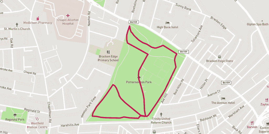
This is the official Potternewton parkrun route that takes in the lush greenery of Potternewton park. And there’s plenty of hills to. Nearly all of the route is on paths apart from a short trail section at the top end of the course.
Before you pop down on a Saturday morning for a 9am start signup and print your runners barcode for free over at the Potternewton parkrun website.
Wanting to find your way to the start of the route? Here is a link for a Google Maps Directions page.
This route has a distance of 1.82km and an elevation gain of 44m.
The largest non-stop incline begins near the start of of the route, and has a distance of 260m and an elevation gain of 19m. You can see this on the above elevation chart in red.
The largest continual decline is 352m long with an elevation drop of 21m which starts in the second third of the route. This is shown on the chart as green.
Route Highlights
One of the biggest highlights of running the Potternewton parkrun 5km run route is the number of hills. These ups and downs might look unappealing before you start, but eventually running these will give you confidence and endurance. In turn you'll get better at running bog standard flats. Thank us later!
Best Time To Run
Just like parkrun, which runs every weekend throughout the year (rain, shine or snow!) we recommend that you run the Potternewton parkrun 5km at anytime of the year. The park changes with the seasons - it's a beautiful space so close to the centre of Leeds!
Route Description
The route starts at the Harehills Avenue end of the park where the pathway drops into a dip simultaneously from both sides. You’ll start on the lowest point in the park and head anti-clockwise towards Harehills Avenue intersection before making a diagonal run up towards the play area. Passing the basketball and skate courts to your right you will take a left after the garden area.
Follow the path around clockwise past the mansion house towards the park entrance off Harrogate Road. Now take the long downhill stretch past the tennis courts on your right. At the bottom head right up the hill towards the Harehills Avenue end of the park before running downhill back to the start. That’s one lap, just two and three quarters to go!
parkrun
parkrun welcomes runners, joggers and walkers from all over the world. At the start of a parkrun event on a Saturday morning you’ll hear a shout out for any parkrun tourists. It’s not uncommon to hear another nationality shouted out!
Warnings
In poor wet weather there’s a good chance that the pathways will get a little slippy under foot. Autumns the worst time for this because the leaves are falling – stride carefully to avoid a fall.
The bottom end (Harehills Avenue) of the park is prone to flooding where the three paths meet the lowest point. On days this happens the route becomes impassable.
Location
Potternewton Park is a large park of 32 acres in the Harehills and Chapeltown area of Leeds. It’s only 2-miles from the centre of the city. The park is famous for being home to the longest running West Indian carnival in Europe.
Amenities
The nearest toilet open Monday-Saturday is over at the Reginald Centre (Google Map Directions) – a couple of minutes walk up Harehills Avenue. You can also print your parkrun barcode at the centre for free.
Parking
There is no official parking for Potternewton Park. We recommend checking out the following two residential streets close by to the park:
- Avenue Hill, postcode: LS8 4EY (Google Map Directions)
- Newton Park View, postcode: LS7 4HL (Google Map Directions)
Food and Drink
On Roundhay Road a short distance from the park is Maureen’s where you can get some of the best West Indian home cooking in Leeds to eat in or take out. If you want to stay the Chapeltown Road side of the park you can head towards the intersection off Harehills Avenue and pop into Kalabash to try their bakery bites.
