Route Elevation
Overview
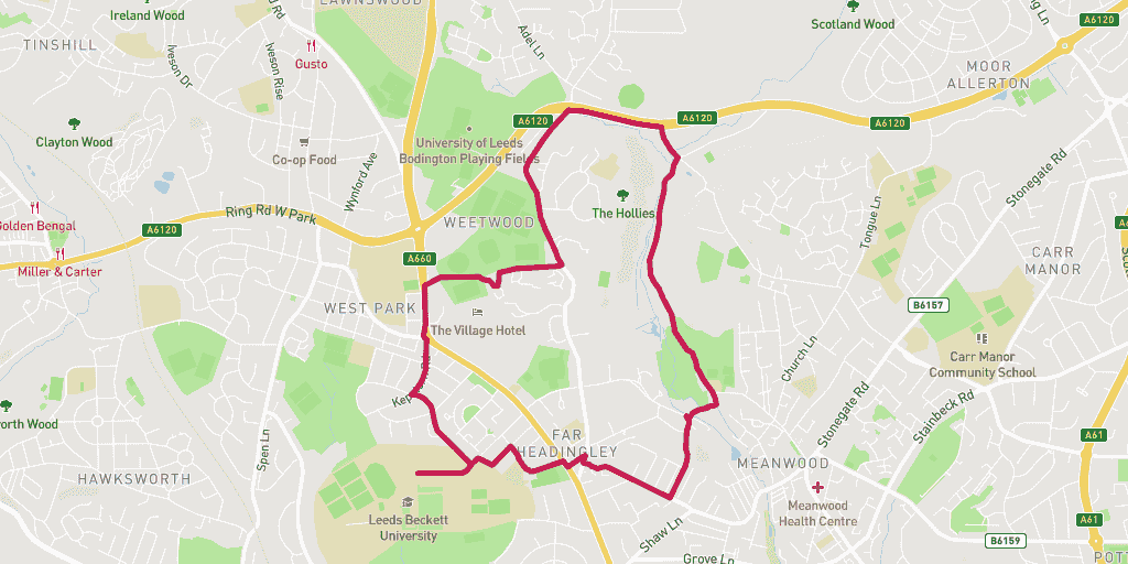
The Weetwood Loop is a mashup of road, trail and parkland. The gradient will climb and drop amid an attractive backdrop of the inner city greenspace. Take your time to soak up your surroundings on this run!
Wanting to find your way to the start of the route? Here is a link for a Google Maps Directions page.
This route has a distance of 6.31km and an elevation gain of 128m.
The largest non-stop incline begins in the final third of of the route, and has a distance of 349m and an elevation gain of 28m. You can see this on the above elevation chart in red.
The largest continual decline is 333m long with an elevation drop of 26m which starts in the second third of the route. This is shown on the chart as green.
Route Description
This route covers some of the best beauty spots in and around Headingley. Start by dropping down to Otley Road get onto Weetwood Lane parallel to the A6120 – re-joining it just before hitting the Meanwood Valley trail off Parkside Road. Take the trail all the down to Meanwood Park where you will cross the Beck and enter the Hollies footpath, via Hollins Allotments. Return to Headingley Campus by taking the up hills of Moor Road and St Chads Road.
Warnings
The Meanwood Valley trail has some really ancient trees on the route. As beautiful and mystical as these are there’s a good chance some of these roots are gangly enough to leave you tripping into a ball of confusion. Watch your step!
Location
You start and finish your run in the historic grounds of Leeds Becketts Headingley Campus.
History
The campus has a long history. It has passed hands from one rich owner to another several times since the 16th century – most notably a full house remodel by William Beckett in 1832 – before the Grange was bought by Leeds Corporation (aka Leeds City Council) in 1908.
It turned into a Teacher Training College in 1913. Throughout the First World War, the College was used as a military hospital. In time the College connected with other local colleges to form Leeds Polytechnic, becoming the Headingley campus we know today.
If you like running in this area, why not take a look at some other routes in similar areas. This route went through: Headingley.
Amenities
The nearest toilet to the start and finish of the run is at Headingley Campus at the Leeds Beckett Student Union.
Parking
Park for free just outside the campus on the residential street of Church Wood Avenue, postcode: LS16 5LF (Google Map Directions)
Food and Drink
Just down the road from Headingley Campus is Otley Road. A student on campus will be aware of the “Otley Run” that tours all the pubs down this long road.. Yet this route into town has some impressive cafes and coffee stops on it.
Food & Drink
Two of our top picks on Otley Road include the fantastic slow pace of Fika North coffee shop and the community atmosphere at Sebby’s café deli. Both places are perfect stops to enjoy your post-run endorphin hit with a drink and bite to eat.


