Overview
This official parkrun run route has gentle inclines and declines, both ups and downs are great for training on.
If running the parkrun event on a Saturday, you will need to signup for free over at Rothwell parkrun.
Wanting to find your way to the start of the route? Here is a link for a Google Maps Directions page.
This route has a distance of 4.37km and an elevation gain of 87m.
The largest non-stop incline begins in the second third of of the route, and has a distance of 200m and an elevation gain of 10m. You can see this on the above elevation chart in red.
The largest continual decline is 159m long with an elevation drop of 9m which starts near the end of the route. This is shown on the chart as green.
Route Highlights
A highlight of running the Rothwell parkrun 5km is the park itself. Located close to Rothwell Country Park - another beautiful green space! Springhead Park offers both recreational opportunities to get involved in non-traditional and traditional sports. And it has peaceful areas like the banks of the beck waterway where you can disconnect after your run.
Best Time To Run
The Rothwell parkrun 5km is an all year all rounder. Due to the paths being part gravel and part tarmac sections of the course are at risk of waterlogging. We prefer running it on a sunny dry day!
Route Description
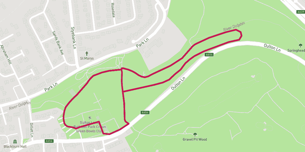
Starting at the bottom end of the car park, this route runs clockwise around Springhead Park.
Follow the loop for two and a half laps before turning right half way across the park and then left to the finish line. You will run over a mixture of crushed stone and tarmac paths.
Springhead Park has lots more things to do other than running. While running the parkrun route you might notice the tennis courts and skatepark.
parkrun
parkrun is really good at doing three things for your wellbeing. You do it with friends, you complete and achieve a challenge, and you overall feeling of “I can do” rises.
Warnings
Springhead Park can get busy on weekends. Especially on sunny mornings. You’ll need to keep an eye on other park users on the footpaths.
If it’s been raining, sections of this route will accumulate puddles and mud, which will make it more difficult running it under foot.
Location
Springhead Park is a large public park in Rothwell, Leeds with a selection of formal gardens and natural countryside. Located just of the roundabout into Oulton has free parking, tennis courts, skate park and a café. Oulton Beck runs along the top of the park.
Springhead Park was built with the funds of both the West Yorkshire Miners Union and welfare committee.
Amenities
There are toilets at The Pavilion café located at the bottom left of the park next to the tennis courts.
Parking
There is on site car parking located just off Oulton Lane. Postcode LS26 0EA (Google Map Link)
Food and Drink
There is a café on site called The Pavilion. It is open 7-days a week serving homemade food as well as a selection of warm and cold drinks. Further afield are several pubs, the closest being The Three Horse Shoes – expect hearty pub grub classics with produce locally sourced.


